
")
Gilbert Rossi, Parc National du Mercantour
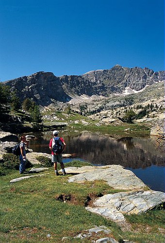
The Maritime Alps are a paradise for hikers. Almost all the summits, even the highest ones (over 3100m, 11500ft) can be reached simply by walking, with no climbing and without the hands. You will see eagles, chamois, marmots. You're unlikety to see the wolfes, though.
But there is not only the high moutains to discover here. From the trails along the sea to the walks around the inland villages, a large variety of possibilities exists.
You can download for free the Departemental Council guide-books giving hints and information about them. They're in French but with maps and pictures.
Or you can use this 3D site of the same Council to choose your next hiking.
Weather
Let's start with this advice: in the Mountains, it is very important to take into account the weather. Thunderstorms can develop very quickly and fog can change so much the landscape as to confuse you and get you lost. Check the weather forecast before leaving. Don't use the coast forceast since the weather can be very different. Check the forecast the day when you hike, not several days before. Also remember that the forecasts in the mountains are not as reliable as elsewhere. If you see a storm building up, believe what you see, not what the forecast said.
You can get the local forecast using Meteo France , the official agency and selecting the name of the city where you'll be hiking, for exemple Belvédère or St Etienne de Tinée in the drop down menu. The drawback is that this site is so overloaded with advertising such as videos...
Beware. Even in summer there is snow high in the mountains. Sometimes it's only small areas, but it's dangerous all the same (see below).
Maps
Nothing compares with a chart and you must have one to hike in the mountains. If the weather changes and you get lost, your map will be your only way home.
There isn't much choice. You will use the maps produced by the IGN, the French Geographical Institute, a public institution. The scale is 1/25000, meaning that one cemtimeter on the paper represents 250m in reality. Therefore they have all the details you will need. They cost around 12€ per chart and there are 16 of them for the whole Maritime Alps. Of course you don't need them all.
It is a good idea, too, to have an other map (1/100000 or 1/75000). It will enable you to identify the mountains you will see from the summit and which are too far to be on your 1/25000 map. The 1/75000 is more precise but it depicts only the Northern half of the Maritim Alps, unlike the 1/100000 which covers the whole area in one chart. (But a little part, North of St Etienne de Tinée.)
You can order right now your charts.
Hiking for the rookies
If you have never hiked in high mountains in summer, here are a few advices for beginners.
First : check the weather. (See above).
Trails are shown by yellow lines painted on rocks or trees. The GR, or Grande Randonnée trails (great hiking) are shown with red and white markers.
You will also see piles of stones, called "cairns' (say kern) along the trails. You can add your own stone. When the weather is nice you may wonder why they're there. But if it turns foggy...
Neither these marks nor the wooden signs along the trails can be a substitute to a map. That's the opposite: the map will show you exactly where the wooden sign in front of you is, thanks to its number.
In the mountains it can be quickly cold if a cloud hides the sun. Take a windbreaker and a sweater. Bring much water, altitude dehydrates. Bring food too, of course.
To cross a snow patch is hazardous, even if it's only 4 meters wide. The risk is to glide on the snow and, with the speed, to break oneself on the rocks under it. It kills. Be cautious and walk slowly on the snow.
If you take children along, choose a short enough hike. It's better to stop before they are exhausted. Remember that going down is almost as tiring as climbing, but not for the same reasons. Your muscles will have to work in an unusual manner to slow you down and it will hurt everywhere even the next day if you're not used to it.
In the next pages a few ideas.
All these hikings can be done within one day (return hike included). There are dozens of them. We had to choose to present you with a short list, not a catalogue. Not easy! This is our opinion only. Use the links on the previous page to find other hikings which will please you.
- The Mount Clapier (3045m)
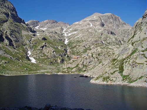
Lake Niré, refuge of Nice and above, the pyramid of the Mt Clapier. Pict. Parc National du Mercantour - Franck GUIGO
This summit will reward you with an unforgettable view on the Alpine Arc, Northward, as far as Switzerland, if the weather permits and there are no clouds and no mist over the Po valley. That's when you must hike there. The panorama will include the Mont Blanc, highest summit in Europe, the Monte Rosa, second highest summit in the Alps, and the Cervino/Matterhorn. The view is great southward too, on Authion, Mt Bego, Mounier etc....
On your way up to the summit you will cross a large area of stones and rocks but you will never need your hands. You will pass along the Niré lake and the refuge de Nice (Nice shelter) Map: IGN 3741OT Vallee de la Vesubie - The Mount Mounier (2800m)
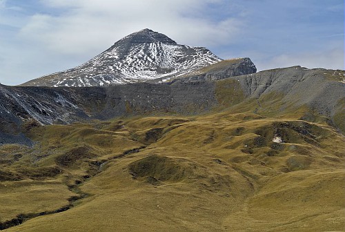
Photo Parc National du Mercantour - Robert VALLARCHER
At 2800m, at the center of the Maritime Alps, you see it from everywhere and when you're there you have a breathtaking 360° panorama on the Maritime Alps and beyond (Ecrins...) You can hike there from Valberg (the easiest and the shortest), or from Roya, North, much longer but much more beautiful and wilder. It's hiking only, never hand climbing. Chart : IGN 3640OT HAUT CIANS/VALBERG - Les lacs de Vens (Lakes of Vens)
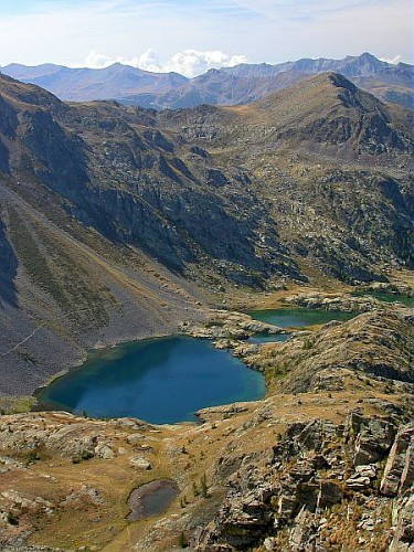
Photo Parc National du Mercantour, Anthony TURPAUD
This hiking departs from a parking lot in the high Tinée valley North of St Etienne de Tinée. It will lead you to a wonderful serie of mountains lakes. It is fairly easy, but expect nonetheless 900m of difference in height to the 1st lake.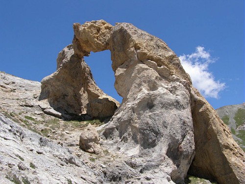
Photo Parc National du Mercantour Elise MINSSIEUX.
Brave men and women who are willing to go further will see a natural arch. (This is not Arch Canyon, of course, but it is several meters wide.) It's walking only all the way up. Map: IGN 3639OT HAUTE TINEE 1 - The Vallée des Merveilles (valley of wonders)
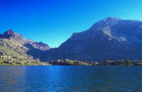
Photo Guy LOMBART - Parc National du Mercantour
Here you are not only in a wonderful landscape with lakes and mountains but also in an open air museum since the valley houses 40,000 rock engravings, more than 3000 years old. You can access this valley from the Roya valley, or from the Gordolasque valley, walking all the way up and down the Arpette pass. Map: IGN 3841OT Roya-Vallée des Merveilles - The Mount Gélas (3143m)
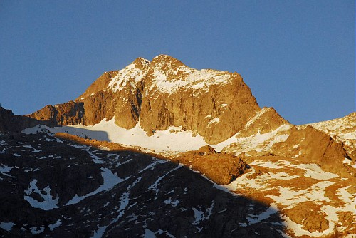
Le Gélas et son sommet fendu caractéristique. Photo Parc National du Mercantour, Franck GUIGO.
This is the highest summit in the Mercantour mountains in France. The real top is the Mt Argentera, in Italy. It will be just in front of you, North. The final gully is one of the few places where you will have to use your hands in the area. In this gully there are risks of rocks falling, too, especially if other climbers are above you.
If you can't or don't want to make the summit, you can stay on the Gelas Balcony, just under this last gully, more than 3000m high. It offers great views Northward and Southward. The view Westward is blocked by the summit, though. The departure for this hiking is in the Madonne de Fenestre valley. Chart: IGN 3741OT Vallee de la Vesubie
Once more a selection, not a comprehnsive list. See the first page to find links towards other hikings in the back country.
These hikings can be done in half a day. You'll not go as high as in the high mountains, so that they will be void of snow sooner in Spring.
- Pic de Courmette
The start is in Tourette sur Loup. The bravest will start from the village and will climb around 800m on a trail. (The top is at 1250m) the others will use their car on the first part until the "Domaine de Courmettes". Then they will have around 300m to climb. The end is fairly steep but you will never need your hands.
From the top you will enjoy an extraodinary panoramic view on the Coast, from Nice to the Esterel, West of Cannes. On the West there are the Gorges of the Loup river. North, it's the Cheiron mountain and also the Mercantour summits. 1/25000 map : IGN 3643ET Cannes, Grasse - Baou de St Jeannet
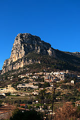
It looks like the prow of a huge rock vessel. The top is at around 800m high. The start is in the St Jeannet village, at the foot of the baou. From the top, view on the Coast from Nice to the Esterel, the Mercantour summit in the North, but no gorges here, unlike the Pic of Courmette. The trail is easy to find in the village with signs all along. If you want a map it's this one : IGN 3643ET Cannes, Grasse - The real Route Napoléon
If you like History, walk in the Emperor's footsteps on his way back to seize power without shooting a single bullet after his return from the Island of Elbe, on one of the last part still intact of the real itinerary he used. (St Vallier de Thiey). Don't go for the view though. There is much better elsewhere in our region.
Once again, this is a selection, not a comprehensive list. See the first page of this article to find links towards other hikes on the Seaside.
For these ones, you won't need a chart.
- The loop around the Cape Ferrat
There is a path wich enables one to walk around the Cape Ferrat. It's a very nice walk, easy on the Eastern side, a little steeper West. Beware the sun and don't go there if the wind blows too much or the Sea is too agitated. You can also walk around the Cap Martin . According to us, if you have to choose, rather choose the cape ferrat. The views are more varied and more interesting. - The Sea Path of Cap d'Ail
It looks like the loop around the Cape Martin. You walk under beautiful villas, just above the Sea. It's an easy walk, not a hike. Beware the sun and strong winds.