
")
(Image Métropole Nice Cote d'Azur)
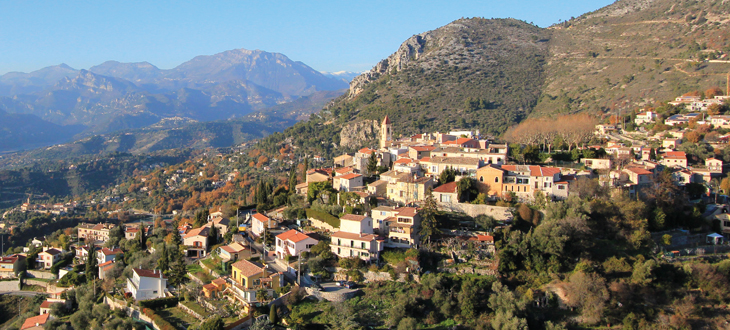
Aspremont is a perched village, 15km from the heart of Nice, on the flanks of the Mt Chauve. It offers wonderful views on the coast and the mountains. The village is 510m high. The top of the commune is 880m high.
From the village, you will see the western part of Nice, all the shore until the Cape of Antibes, the Lerins islands, the Esterel mountains and, with a clear sky, summits in the Maures mountains, 95km from you. The Baou of Vence, the Baou of St Jeannet are also visible form the village. On the North West, the Mt ST Honorat (2500m) and the Grand Coyer (2650m) are visible, more than 40km from the village.
The best way to enjoy the view is to take the avenue Caravadossi which rises from the parking, and in front of the town hall (Mairie). Follow the red and white signs in the uphill direction. A shortcut on the left in the first hairpin bend enables walkers to avoid staying on the road without sidewalks. You'll arrive "Place des Salettes", near a little chapel, with the promised great view and the village in the foreground.
Aspremont allows for nice walks in the village with carless narrow streets and stairs.
It is also a good starting point for two fairly easy hikes. Both of them depart from the parking at the entrey of the village and follow the GR5, which goes from Nice to the Netherlands. (GR are marked with red and white signs.)
- Southward, you will climb towards the pass between Aspremont and Tourette Levens before you turn right to follow the trail going up on the western flank of the Mt Chauve (880m). After serevral kilometers, you will reach the cross traill with the trail, on your left, going to the summit, with a breathtaking view on Nice and the coast.
- Northward, you will reach the Mt Cima, a summit very similar to the Mt Chauve, almost at the same altitude. The beginning of the hike is the same as to go to the PLace des Salettes. A large part of this hike is made on wide unpaved roads. There are shortcuts for pedestrians if you don't mind trails. You walk around a first summit on these roads, and then see the Mt Cima. At a point, you have to make a right on a narrow trail. Beware, there is no sign because you are leaving the GR5. From the summit, there is a 360° view. Nice is not visible because the Mt Chauve obstructs your view. But you see everything else, including the Mercantour Alps with their summits over 3000m high. Even better : there is a viewpoint diagram to help you identify what you see.
On June the 27th 2020 the village will see three times the cyclists during the first stage of the Tour de France.